Exploring the Majestic Tahoe Rim Trail: A Hiker’s Paradise in the United States.
The Tahoe Rim Trail, nestled amid the stunning landscapes of the United States, provides an unrivaled outdoor experience for nature aficionados and adventure seekers alike. This 165-mile trail winds its way around Lake Tahoe, passing through lush woods, alpine meadows, and steep hills.
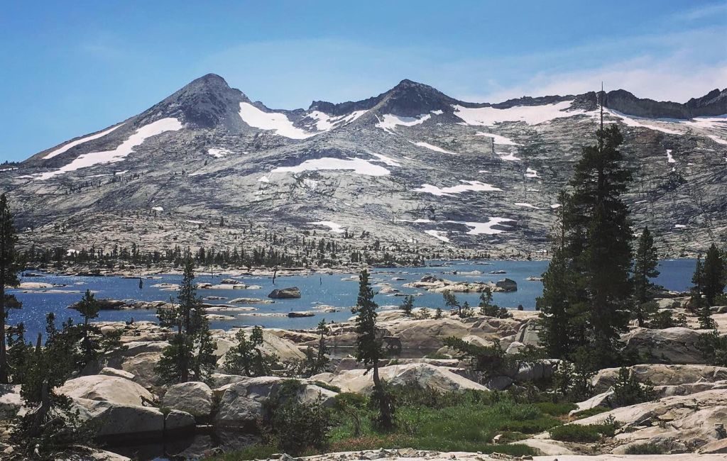
Photo by Rebecca Cook
We’ll delve into the mysteries of the Tahoe Rim Trail in this detailed tour, studying its history, attractions, obstacles, and the unique beauty it reveals.
Brief History
A 165-mile single-track trail called the Tahoe Rim Trail (TRT) surrounds Lake Tahoe in California and Nevada. Glenn Hampton, an outdoor recreation officer with the U.S. Forest Service’s Lake Tahoe Basin Management Unit (LTBMU), made the initial suggestion in 1978. The route was finished in the month of September 2001, with construction formally starting on the fourteenth of July 1983. This construction was done by volunteer labor.
A hardworking team of volunteers worldwide developed the Tahoe Rim Trail. Over 10,000 individuals worked on the project for more than 200,000 hours. The volunteers were of different ages. Some as young as 8, others as old as 80. They also came from different backgrounds. They overcame numerous obstacles while working in a variety of weather conditions. But their perseverance and tireless effort paid off, and today, the Tahoe Rim Trail is among the most well-liked hiking routes on the planet.
Description of the Sight
As mentioned at the beginning of this article, the Tahoe Rim Trail runs for 165 miles around Lake Tahoe. This trail covers two states, six counties, one park, three national forests, and three wilderness areas. Forty-nine miles of it cross the Pacific Crest Trail. A network of other trails joins the Tahoe Rim Trail. Wildflower exhibits can be seen on or near the TRT as it travels through meadows, conifer woods, rocky slopes, and mountainous terrain.
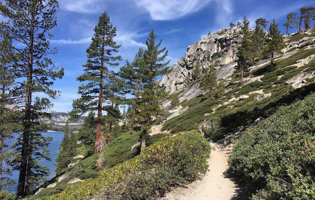
Photo by Rebecca Cook
The TRT is one of the best routes in the world, and it surrounds one of the most picturesque lakes on Earth. When ascending the TRT, you will be exposed to breathtaking views of Lake Tahoe and limitless landscapes to all directions of the compass, from 6,300 ft in Tahoe City to 10,338 ft at the summit of Relay Peak, the elevation changes along the course. The TRT provides access to several creeks, lakes, mountains, and meadows. The variety of ecosystems and altitude provide a wide variety of wildflowers.
Each of the eight trail sections that make up the continuous circle in the highlands above the lake is accessible from ten designated trailheads by car. The lengths of the sections vary from 12.2 to 32.5 miles. Unauthorized entry points offer another way to access the trails. Using the TRT is a terrific opportunity to get outside and enjoy wildflowers, fungal organisms, or fall colors, whether you hike farther or walk only a few kilometers from the trailhead.
Ways to Get There
Drive or bike to one of the ten approved TRT trailheads to access the hilly loop above Lake Tahoe. From there, hikers can explore every inch of the path, which ranges in elevation from 6,300 feet to 10,338 feet, over eight trail segments ranging in length from 12.2 to 32.5 miles. The flora and fauna, as well as the landscapes, are different across this span.
Each turn of this journey causes the eyes to float through stretches of surreal splendor.
You don’t have to be an experienced hiker to take on this trek. All levels of hikers can successfully complete the TRT. Despite the length of the trails, visitors can enjoy the scenery for as long as they can before returning to the trailhead. You can also bring your pet as long as they behave themselves and are cared for when they make things messy.
It should be noted that mountain bikers and horseback riders can also reach some parts of the TRT. Finding out which trails are for hikers to have a smooth journey is recommended.
Details on hiking Tahoe Rim Trail
The California-Nevada border is crossed twice along the Tahoe Rim Trail (TRT), used by trekkers, travelers in backpacks, bike riders, and horseback riders. The trail’s elevation ranges from 6200 feet in Tahoe City to Relay Peak’s 10,338-foot summit.
For mountain cyclists, the track offers a range of terrain and difficulties, including some parts with an elevation rise. Amazing ridge rides above granite peaks, easy single track through lush green meadows, and breathtaking sights of one of the world’s cleanest water sources are all found here.
The only stretch of the TRT that needs a permit is the Desolation Wilderness section. Fortunately, the Lake Tahoe Basin Management Unit offers permits expressly to thru-hikers that avoid the standard DW permit procedure because it’s such a popular spot to travel.
When to Go: Weather and Season
Although summer is lovely, wildflowers can be best seen between July and mid-October. When the temperature drops between September and October, fall colors are visible. Watch for young animals and plants emerging through the spring and early summer landscape. The TRT website contains a detailed explanation of each trailhead and what may be observed there.
The Tahoe Rim Trail is always open; snow-covered sections are frequently harder to access and need cross-country skis or snowshoes.
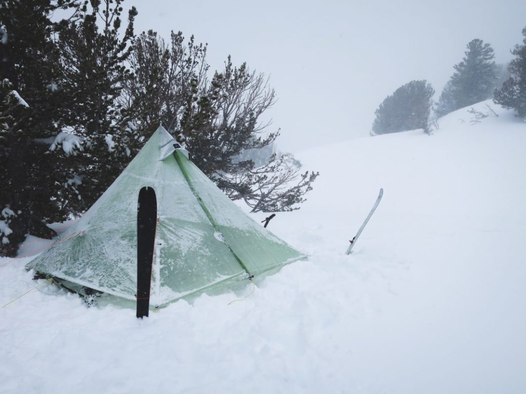
Photo by Justin Lichter.
Accommodation
Suitable shelters may not be available on the Tahoe Rim Trail. However, on the majority of the path, dispersed camping is permitted. Please take note that it is not permitted to camp at trailheads.
Three established rustic campgrounds—Marlette Peak, Hobart, and North Canyon—are the only places where camping is permitted within the Lake Tahoe Nevada State Park. This area is a region on the lake’s eastern shore). Along the Tahoe Rim Trail, several campgrounds provide an affordable choice for lodging. The Tahoe Meadows Campground, Spooner Lake Campground, and Brockway Summit Campground are well-known campgrounds.
There are two hostels in South Lake Tahoe, which is a nice spot to resupply, but no shelters are on the trail. For those arriving by plane or train for their thru-hike, there is a lodging facility in Truckee and another in Reno. The Hyatt Regency Lake Tahoe Lakefront Resort, the MontBleu Resort Casino & Spa, and the Heavenly Mountain Resort are just a few hotels and motels close to the Tahoe Rim Trail. These hotels provide a range of facilities, such as restaurants, fitness centers, and swimming pools.
Food and Water
Along the Tahoe Rim Trail are a few locations where you can buy food and drink, but it’s best to pack your own supplies. Some of the locations where you can obtain food and water are mentioned below:
Trailheads: The majority of trailheads feature water fountains and bathrooms. Small shops that offer food and beverages are also present at certain trailheads.
Camping areas: Most camping areas along the path offer shops for groceries and water.
Resupply locations: You can purchase food and beverages at a few resupply locations along the path. These replenishment locations are frequently found at trailheads or campers.
Lakes and streams: You can discover water from lakes and streams along the walk. Before consuming the water, it is crucial to filter or cleanse it.
It is significant to remember that there are portions of the Tahoe Rim Trail where supplies such as water and food are difficult to come by. These sections of the path are frequently seen in farther-flung locales. Having a lot of nourishment and fluids with you is crucial if you intend to hike in these locations.
Challenges When Hiking Tahoe Rim Trail
Some of the challenges of hiking the Tahoe Rim Trail include the following:
High elevation: The TRT has a 24,400-foot elevation gain, which is a substantial amount for a 165-mile path. This implies that you will be undertaking a lot of challenging uphill hiking.
Wide range of landscapes: The TRT travels across various landscapes, including alpine slopes, woodlands, and meadows. This implies that the terrain you hike will vary, involving rocks, dirt, and tree roots. This can be difficult if you’re unfamiliar with hiking on uneven terrain.
Weather: The weather in the Tahoe region is erratic and subject to sudden shifts. This may make hiking the Tahoe area unfavorable. To overcome this challenge, you must be ready for all types of weather, such as rain, snow, and strong winds. You also need to be appropriately clothed.
Wildlife: A variety of animals, such as bears, mountain lions, and deer, live in the Tahoe region. To prevent contact with wildlife, you must be conscious of your environment and adopt safety measures.
Tips to know when hiking Tahoe Rim Trail
- Begin small: Begin with shorter hikes along the trail if you are not accustomed to big hikes. You can do this to increase your stamina and get ready for more strenuous hikes.
- Group hiking: It can be beneficial if it is your first time on the route. A group can offer companionship and support when you are lonely. Discussions within the group can serve as a forum for learning. It may also be helpful in emergencies.
- Recognize your surroundings: The Tahoe region is home to various species, so it’s critical to be conscious of your surroundings and take safety measures to prevent wildlife encounters.
- Examine the weather before heading out: The weather in the Tahoe region may be erratic, so looking at the forecast before going on a hike is crucial. Well, sometimes forecasts can be wrong. So what you may have to do is to be weather-ready. You should take some sunscreen just in case the weather is hot and rain gear in case it rains uncontrollably in order to cope with the unpredictable weather.
- Pack the required equipment: Pack the essential hiking supplies, such as food, water, a first-aid kit, a map, and a compass.
- Take breaks: It is crucial to pause when hiking, especially if you’re covering a lot of ground. Taking breaks will assist you greatly in staying hydrated and active throughout the drek.
- Get the right equipment: The TRT is a demanding and lengthy hike; therefore, it is crucial to have the right equipment. This entails a sturdy backpack, hiking shoes, and abundant water and food.
- Follow the “Leave no trace” principle: Since the TRT is a well-traveled path, it’s crucial to conceal your existence. This entails taking out all of your waste and being environmentally conscious.
- Recognize the laws and regulations: Hiking in the Tahoe region is subject to several laws and rules. Before you go trekking, ensure you are aware of these guidelines and adhere to them.
Potential Dangers
Some of the potential dangers of hiking the Tahoe Rim Trail are as follows:
- Navigation and orientation: The Tahoe Rim Trail travels across various terrains over a span of about 165 miles (265 kilometers). You must be skilled in navigating and always have a detailed map, a compass or A GPS gadget with you. It can be perilous to become lost or confused, especially in isolated locations with poor cell phone coverage.
- Limited Water Sources: During dry weather, several portions of the path may have limited water supply. This can pose a danger, especially when you are in dire need of water either to quench your thirst or to use it for something else. To carry sufficient fluids between dependable sources, hikers need carefully arrange their water refill stations. To prevent waterborne infections, it’s crucial to sterilize or filter water that comes from natural sources.
- Remote Locations: Some parts of the trail are out in the wilderness and distant from help. It could take some time for aid to come in the event of an emergency or injury. A fully equipped first aid kit, fundamental wilderness survival techniques, and a strategy to send messages or warning signals are all essential.
Conclusion
The Tahoe Rim Trail is a haven for outdoor enjoyment. It makes access to a staggering variety of geology, vegetation, and animals possible.
It is an exceptional hiking location that offers unmatched wilderness experience, physical challenge, and natural beauty. For outdoor enthusiasts seeking adventure and seclusion, it may be an unforgettable experience with careful planning and preparation.

